
Updated: National Weather update on 95L
Last updated 9/11/2018 at Noon
Update 12:50 pm
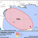
As of 1230 pm Tuesday, the National Hurricane Center has increased the chances for tropical development in the western Gulf of Mexico to a high (70%) chance. A tropical depression is likely to form Thursday and head towards south Texas Friday and Saturday.
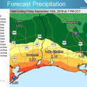
We are expecting a wet forecast to continue through the end of the week. One to three inches of rain is expected, with locally higher amounts. However, if the system that comes in the Gulf comes closer to our region, we could see substantially higher amounts. Stay in touch with the updating weather forecasts this week.
Tides will run a foot above normal. This will result in minor coastal flooding only during periods of high tides this week.
Roger Erickson
Warning Coordination Meteorologist
National Weather Service
Lake Charles, LA
337-477-5285 x223 office
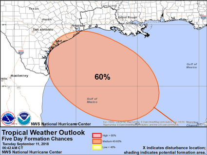
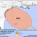
Earlier: The National Hurricane Center continues a medium (60%) chance for tropical development on a system expected to cross the Yucatan Peninsula into the Gulf of Mexico today and tomorrow. This system is expected to reach south Texas late this week or weekend.
What that means for us is above normal rain chances this entire week. Between 2 to 6 inches of rain with locally higher amounts is expected, with the highest values in southeast Texas and southwest Louisiana. In addition, tides will run a foot above normal which could cause some minor coastal flooding during periods of high tide.
The other three systems in the Atlantic, Florence, Isaac, and Helene, are not going to impact our weather over the next week.


Reader Comments(0)