
OC leaders excited by drones’ potential
Last updated 1/8/2019 at Noon
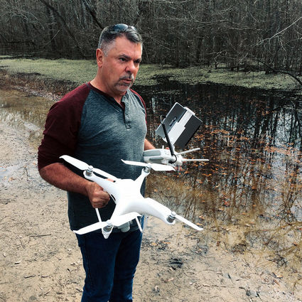
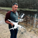
Photo: Orange County officials Joel Ardoin, left, Dean Crooks, Johnny Trahan and Clark Slacum, far right, watch as Beaumont Police Sgt. Mike Custer lands a drone during a flood-mapping demonstration in Orange Monday. RECORD Photo: Dave Rogers
Dave Rogers
For The Record
In the ultimate example of a win-win, the Beaumont Police Department put on a “drone show” for Orange County leaders Monday morning.
Beaumont Sgt. Mike Custer flew one of his department’s four drones over some northeast Orange County roads flooded by recent rains and dam releases.
The goal was to both document the flooding for further study by county officials with video and to demonstrate the possibilities for the Orange County Sheriff’s Office’s own unmanned aircraft fleet.

Three drones, purchased with $25,000 from its assets forfeiture fund, are expected to begin overflights this summer.
“I thought it was great,” Orange County Judge Dean Crooks said of Custer’s show-and-tell.
He was joined for Monday’s “road show” by Sheriff Keith Merritt, Chief Deputy John Tarver, Commissioner Johnny Trahan, Emergency Management Coordinator Joel Ardoin, County Engineer Clark Slacum and Road and Bridge Superintendent Michael James.
It’s a toss-up as far as what Crooks likes best about the soon-to-fly Orange County drones – the utility or the cost.

“Our Sheriff’s Office took the initiative to use seized money, so it doesn’t cost the taxpayers a dime,” Crooks said.
“And arranging for this demonstration from the Beaumont Police is a wonderful example of cooperation between agencies.”
Tarver, the Sheriff’s Office SWAT commander, said Capt. Richard Howard will be in charge of OCSO’s drone program. Tarver said the three drones the county ordered have arrived in Orange.
But the five or six assigned drone pilots won’t begin training until the end of February and then will need some time getting used to the machines before commencing their official duties.
“When I first started thinking about the drone program for the Orange County Sheriff’s Office it was to utilize the drone in my capacity as SWAT commander, ways not to put my men in jeopardy,” Tarver said.

“We can put our drones in some of those situations where we don’t want to put a life at risk. We can use it for mapping crime scenes.”
Merritt and Tarver presented the drone project for approval to county commissioners in October. They mentioned it could also be used by other county departments for other uses.
“I think the possibilities are only limited by technology,” said Trahan, the commissioner whose Precinct 1 was the site of the morning flights over Pine Bluff, West Bluff and Pea Farm Roads. After a lunch break, Custer took his drone to survey high water on the northeastern side of Orange County, near the Neches River.
“The drone could be used for assessment during a major event,” Trahan said. “If we can get the county Geo-mapped, it could even give us the depth of water using the GIS (geographic information system) map as a measuring tool.

“It could help us locate stranded or missing people.”
Ardoin said the mapping being done Monday could be used to help them document, predict and, hopefully, prevent damage in the future.
“We’re going to attempt to get some for Emergency Services as well,” he said. “We hope it never happens again, but if we do have people who need to get rescued, we can use drones to assist in locating them.
“An assessment of flooded streets like today can give us an idea of what to expect with these rain events. We can get an idea when they open the [reservoir flood] gates at this level, what we can expect.

“Another good function would be damage summary outlines after a [disaster] event.”
Slacum, the head of the Road and Bridge Department, pointed out his department could use drones to video and show the condition of county roads before a disaster, which would help in seeking FEMA reimbursements.
Custer said Beaumont had invested $30,000 in four drones in the two and a half years they had been in use. A large drone that included thermal imaging capability cost nearly $25,000 by itself.
He said drones like the one used Monday that could shoot and transmit in real time video and still photos cost about $1,000 each.
Orange County’s Tarver said its drones came from the same manufacturer as Beaumont’s, DJI, and about $20,000 of the initial $25,000 investment went for one large drone ($11,000) and a thermal imaging camera ($9,000) for use in search and rescue or SWAT operations.

“Our drones came in very handy during [Tropical Storm] Harvey,” Custer said.
Reader Comments(0)