NASA and Hurricanes: Five Fast Facts
Last updated 6/8/2021 at 7:53pm
The 2021 Atlantic hurricane season began on June 1. Our colleagues at NOAA are predicting another active season, with an above average number of named storms. At NASA, we’re developing new technology and missions to study storm formation and impacts, including ways to understand Earth as a system. The following are 5 Fast Facts about NASA and the 2021 hurricane season:
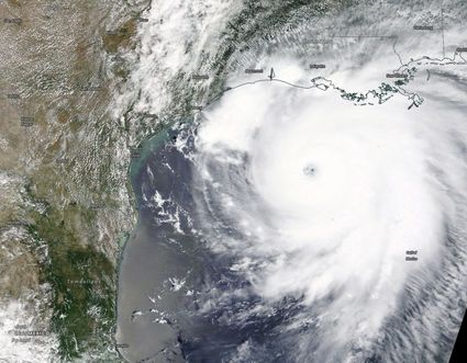
1. NASA can see storms from space.
From space, NASA can see so much more than what’s visible to the naked eye. Among NASA’s missions, NASA and NOAA have joint satellite missions monitoring storms in natural color -- what our eyes see -- as well as in other wavelengths of light, which can help identify features our eyes can’t on their own. For instance, images taken in infrared can show the temperatures of clouds, as well as allow us to track the movement of storms at night.
2. Satellites can see inside hurricanes in 3D.
If you’ve ever had a CT scan or X-ray done, you know how important 3D imagery can be to understanding what’s happening on the inside. The same concept applies to hurricanes. NASA’s Global Precipitation Measurement mission’s radar and microwave instruments can see through storm clouds to see the precipitation structure of the storm and measure how much total rain is falling as a result of the storm. This information helps scientists understand how the storm may change over time and understand the risk of severe flooding.
3. We’re looking at how climate change affects hurricane behavior.
Climate change is likely causing storms to behave differently. One change is in how storms intensify: More storms are increasing in strength quickly, a process called rapid intensification, where hurricane wind speeds increase by 35 mph (or more) in just 24 hours.
In 2020, a record-tying nine storms rapidly intensified. These quick changes in storm strength can leave communities in their path without time to properly prepare.
Researchers at NASA JPL developed a machine learning model that could more accurately detect rapidly intensifying storms.
It’s not just about how quickly hurricanes gain strength. Scientists at NASA are also looking at how climate change may be causing storms to move more slowly, which makes them more destructive. These “stalled” storms can slow to just a few miles an hour, dumping rain and damaging winds on one location at a time. Hurricane Dorian, for example, stalled over Grand Bahama and left catastrophic damage in its wake. Hurricanes Harvey and Florence experienced stalling as well, both causing major flooding.
4. We can monitor damage done by hurricanes.
Hurricane Maria reshaped Puerto Rico’s forests. The storm destroyed so many large trees that the overall height of the island’s forests was shortened by one-third. Measurements from the ground, the air, and space gave researchers insights into which trees were more susceptible to wind damage.
Months after Hurricane Maria, parts of Puerto Rico still didn’t have power. Using satellite data, NASA researchers mapped which neighborhoods were still dark and analyzed demographics and physical attributes of the areas with the longest wait for power.
5. We help communities prepare for storms and respond to their aftermath.
The data NASA collects is available for free to the public. NASA also partners with other federal agencies, like FEMA, and regional and local governments to help prepare for and understand the impacts of disasters like hurricanes.
In 2020, NASA’s Disasters Program provided data to groups in Alabama, Louisiana, and Central America to identify regions significantly affected by hurricanes. This helps identify vulnerable communities and make informed decisions about where to send resources.
Working together with partners at NOAA, FEMA and elsewhere, NASA is ready to help communities weather another year of storms.


Reader Comments(0)